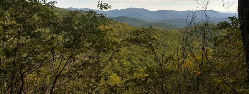
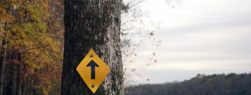
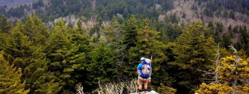
This one is for all the local history buffs out there! This hike takes you past the ruins of Rattlesnake lodge, built in 1904 as a summer retreat for Dr. Chase P. Ambler and his family. Dr. Ambler was an avid forest conservationist and is regarded by many as the father of the Great Smoky Mountains National Park. The trail starts at Bull Gap and follows the Mountains to Sea Trail east. This moderate hike starts with uphill switchbacks, but don’t worry, it levels out.
Early spring is a particularly lovely time to go, as there are a great number of daffodils on the grounds. Spring through fall the trail can be accessed from the Blue Ridge Parkway, but when it is closed during the winter it can be accessed via Elk Mountain Scenic Highway.
Frugal crew member Maggie enjoying the solitude of Rattlesnake Lodge’s “yard”.
Length: 3.8 mi lollipop
Difficulty: moderate
Directions: From Asheville, head north on Merrimon Ave. Turn right on Beaverdam Rd. After 0.6 mi, turn left on Elk Mountain Scenic Hwy. After 7 mi, continue straight on Ox Creek Rd. At 0.2 mi you will see a small pull out on the right. Park here or along the road (be sure your car is all the way off the road) and access the trail from the pull out.
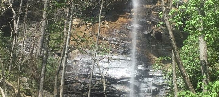
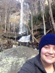
Looking for a hike that’s short enough to do in an afternoon, but challenging enough to keep the crowds at bay? You might want to give Frugal Backpacker Greenville Staffer, Marie’s favorite hike a try – Rainbow Falls. Located in Jones Gap State Park, these stunning falls and offer plenty of space to spread out for a picnic or wade around the base (always use caution on slick rocks and around water).
Marie at her fav trail.
Distance: 5 mile out and back
Difficulty: Strenuous
Directions: From Greenville, head north on 276 toward Caeser’s Head State Park. Continue 2.6 miles past the park and turn right onto Solomon Jones Road. After 4.6 miles, you’ll see a small parking area on the right. Head back about 10 yards and turn left to to access the trail.
Start out on the blue blazed Jones Gap Trail, then after 3/4 of a mile veer right onto the red blazed Rainbow Falls Trail.
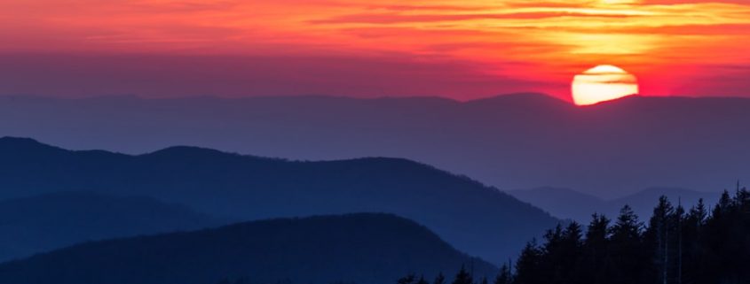
What better way to reward a vigorous effort on the trail—or up a summit—than by sitting back and soaking up the serenity of one of nature’s most beautiful shows? Fortunately, Knoxville has plenty of gorgeous sunset hikes right in its backyard. Whether you’re sticking close to town or venturing further afield, Knoxville is the perfect launching point for your next memorable stroll in the woods. Here are seven recommended sunset hikes in and around Knoxville that are sure to take your breath away.
1. High Ground Park
Probably the best view of the city and well worth the trip. Logan Mahan
This historical landmark in South Knoxville boasts excellent views of the city and is known for its picturesque sunsets. Once the site of Fort Higley, a Union camp constructed in 1863, High Ground Park is bordered today by hardwood forests, native flowering bushes, and a stone wall. To catch the sunset, park in the dirt lot at 1121 Cherokee Trail and follow the gravel trail as it winds its way into the River Bluff Wildlife Area. Hang a right at the first fork, and take your pick at the second fork—either way, will bring you to the overlook and the park’s famous swing. The golden hour light here is phenomenal, and the sunset isn’t bad, either.
2. Sharp’s Ridge Memorial Park
Another close-to-home sunset hike, Sharp’s Ridge offers a panoramic view of the Knoxville skyline, with the postcard-worthy gradient of the Great Smokies in the background. The 111-acre park is just 10 minutes from downtown, and while you can drive to the top of the ridge or the overlook (the sunset, as viewed from this observation deck, is considered among the most beautiful in America), there’s plenty of hiking to be had, too. If you plan to hike for your sunset, head to Sharp’s Ridge in the fall when the leaves have dropped and the mountains are visible from the three-mile multi-use trail below.
At 6,643 feet, Clingmans Dome is the highest point in Tennessee, so you know it’s a great place to catch the sunset. On clear days, the 360-degree views go as far as 100 miles, and sunsets here are breathtaking. The summit is accessible via a steep paved trail, but the Appalachian Trail also crosses Clingmans Dome, so hikers looking for a challenge can watch the sunset, then head to one of the nearby backcountry shelters. The dome is also the western terminus of the 1,150-mile Mountains-to-Sea Trail, so the possibilities for pre-sunset hikes are nearly limitless.
4. Cades Cove
Cades Cove is an excellent place to watch the sunset, either from your campsite or from the summit of Rocky Top (of Tennessee state song fame).
A longtime Cherokee hunting ground, Cades Cove is one of Great Smoky Mountains National Park’s most worthy sights. An 11-mile, one-way loop road circumnavigates the entire cove; bikes are allowed on the road, as well. Several hikes begin at trailheads along the Cades Cove loop, including the five-mile roundtrip hike to Abrams Falls, as well as hikes to Thunderhead Mountain and Rocky Top (14 miles roundtrip to tag both summits), both of which offer fantastic sunset views.
5. Big South Fork National River and Recreation Area
With its dramatic sandstone bluffs, the highest concentration of natural arches and bridges in the eastern United States, gorgeous views of the Cumberland Plateau, and access to the Big South Fork River, it’s no wonder Big South Fork NRRA sees well over half a million visitors each year. Just an hour north of Knoxville, Big South Fork is home to more than 180 miles of trails for hiking and trail running, plus another 35 miles of mountain bike trails. Plan to explore during the day, then drive, bike, or walk to the East Rim Overlook, where it’s a short hike to a stunning sunset vista.
6. Cherohala Skyway
Cherohala Skyway offers access to incredible sunset hikes.
A combination of the names of the two national forests it passes through, Cherokee and Nantahala, the Cherohala Skyway is about 40 miles long and provides access to excellent hiking—not to mention gorgeous sunset vistas. The remote Big Frog Mountain Wilderness clocks in at just under 8,400 acres and include 35 miles of backcountry trails, including several that lead to the summit of Big Frog Mountain itself. The views from Big Frog are spectacular, especially at sunset, and can be reached via the Wolf Ridge, Hemp Top, and Licklog Ridge trails. But don’t get too taken by the unforgettable vistas: This area has tons of black bears, so travel in groups and talk as you head back to the car from your hike after dark to avoid startling one.
7. Loyston Overlook Trail
Less than 40 minutes north of Knoxville, Big Ridge State Park is tucked in the Cumberland Mountains and features 15 miles of forested trails. The Loyston Overlook Trail is short but steep and leads to a lookout above Norris Lake, which now covers the former site of the town of Loyston. The well-marked trails here mean it’s easy to find your way back to the car once the sun has set. But it’s not for the faint of heart—thanks to the park’s haunted history (it’s all in good fun), you’ll want to travel in a group at dusk.
Dedicated organizations such as the Carolina Thread Trail, the Friends of the Mountains to Sea Trail, and the Tarheel Trailblazers are the engines driving new trail projects across the Carolinas. From flat, wide rail trails to gnarly sections of technical singletrack, miles upon miles of new outdoor experiences are constructed every year.
They’ve been so busy in fact, that a complete list of all the new trails would be nearly impossible to curate. Instead, we’ve listed six segments that are interesting for either the trail itself or what’s around it.
1. Love Valley Trail
Love Valley is short but sweet, giving you a taste of the Old West. Rob Glover
Sometimes the trail is only part of a much larger experience, and such is the case for the 2.6-mile stretch of the Carolina Thread Trail known as the Love Valley Trail. Ideal for horseback riding but open to bikers and hikers, this smoothly graded path runs along the southern edge of the Brushy Mountains and begins in Love Valley. The real draw of the area, especially for equestrian fans, is the Old West-themed town center. The dirt road, where only foot and hoof traffic are allowed, is lined with hitching posts, wooden walkways, and saloons. Not what it once was—many of the shops have closed and buildings are for sale—the novelty of seeing a town where the horse remains king is still worth a visit.
2. East Main Extension at the USNWC
Hikers and bikers should watch out for each other along the East Main Extension. Rob Glover
Land acquisitions in 2014 and 2015 effectively doubled the footprint of the U.S. National Whitewater Center located on the western edge of Charlotte. According to its directors, the center plans to protect the land rather than develop it, resulting in hundreds of open acres just waiting for trail designers to work their magic. One of the most challenging recent additions is an extension on the existing East Main Trail. Now totaling 6 miles, the trail includes sharp climbs and swift descents, earning its nicknames “East Pain” and “Beast Main”. All trails at the USNWC are open to foot and bike traffic.
3. Bigleaf Slopes
Volunteer opportunities exist almost every weekend for building new trails all over North Carolina. Bob Ellis
The 2.2 miles of singletrack at Bigleaf Slopes in Statesville, NC is yet another testament to the tenacity and hard work put forth by the Tarheel Trailblazers. Working in conjunction with Iredell County, the superheroes of the singletrack have created another stellar mountain bike park out of the previously unused land. Trail mileage will continue to spread throughout the 104-acre tract, but for now, the ride is fairly fast with moderate elevation changes.
4. Piedmont Medical Center Trail Extension
Get refreshing river views on paths like the Piedmont Medical Center Trail.
The Piedmont Medical Center Trail is one of several dazzling amenities at the Rock Hill Outdoor Center. A recent extension to the trail, made possible in large part by the Carolina Thread Trail, has made it even better. Now connected to existing paths in the adjacent River Park, the system extends for over five miles. Bikers and walkers will find a mix of construction including pavement, boardwalk, and natural surface trail. Flowing alongside the Catawba River and through the forested River Park, the trail offers a serene escape at the outdoor center.
5. The South Fork Rail Trail
Look for different species of plants that live along the trail.
Passing through a Cypress swamp isn’t a common occurrence in the central Piedmont of North Carolina, so catching a glimpse of this unusual biome during a peaceful run on the South Fork Rail Trail is a cool experience. In fact, the swamp setting is just one of several points of interest along the new two-mile, natural surface trail in Lincolnton, NC. Keep an eye out for large leaf magnolias, the remnants of a bridge destroyed by Union soldiers during the Civil War, and the rocky shoals of the South Fork River. This smooth trail is an excellent spot for a morning walk, jog, or short bike ride.
6. MST section along the Haw River
The Mountains to Sea Trail is an incredibly ambitious, 1,150-mile trail housed completely within the state of North Carolina. While the trail is walkable now—dozens have actually completed it—around half the distance requires overland passage. Several new sections of trail are added every year and one of the longest recent additions is the four-mile continuance of the Haw River Trail in Burlington, NC. Following the banks of the placid and rocky Haw River, the trail extension creates a total of eight uninterrupted hiking miles.
https://frugalbackpacker.com/wp-content/uploads/2018/07/cr4myoifmdjsqongwnbw.jpg6961044Frugal Backpacker/wp-content/uploads/2016/04/frugal-backpacker-logo.pngFrugal Backpacker2018-07-25 14:45:002018-07-31 18:33:426 of the Best New Trails in Charlotte
Beginning off of scenic highway 105, the Profile Trail offers hikers an opportunity to witness some of the spectacular and beautiful views the high country has to offer – views famed naturalist John Muir once wrote about in 1898. You’ll start by lightly treading through the headwater streams of the Watauga River as it winds 3.1 miles through seven different types of natural communities, including northern hardwood, Canadian hemlock, and acid cove forests.
What Makes It Great
These forests also house plenty of wildlife and almost 200 different species of birds. Profile Trail hikers can spot woodland species such as Warblers (especially in spring), Scarlet Tanagers, Louisiana Water Thrushes and numerous varieties of Vireos. As the trail continues to spiral up the mountain, you’ll pass a great campsite, numerous breathtaking overlooks, and, my personal favorite, Shanty Spring (a cool and delicious fresh water spring located at about mile 2.7).
The last 0.3 miles will get your heart pumping, calves burning and put you on your hands and knees as you climb up rocks along the steepest part. Once you reach the top of the Profile Trail, you’ll have two options: left or right. Since this is “Profile Trail to Calloway Peak”, you will swing left on the Grandfather Trail. It will take you 0.4 miles along the ridgeline and up three ladders to the summit of Calloway Peak.
Calloway Peak sits at 5,946 ft with the best views of Grandfather Mountain, Linville Gorge and sometimes even the Charlotte skyline. John Muir described the sublime scenery from the summit as, “I couldn’t hold in and began to jump about and sing and glory in it all” and the sunsets here as, “I only went out for a walk, and finally concluded to stay out till sundown, for going out, I found, was really going in.”
Bring some tasty snacks, plenty of water, and good company, and it will be a hike that you won’t regret.
Who is Going to Love It
This trail is for nature, adventure, and hiking enthusiasts. You’re gaining about 2,000 ft of elevation from start to finish. You’ll want to have comfy hiking boots and a backpack full of water and your favorite snacks to stay fueled along the trail. If you have any knee or leg problems, I suggest bringing trekking poles for additional support. There are benches along the trail for when you need a breather. It is well maintained and well traveled, although the last 0.3 miles can be rocky and uneven.
Directions, Parking, & Regulations
There is an official parking lot for this trailhead. Since this is a hiking favorite, I would suggest getting there early to secure a parking spot; the parking lot fills up quick. If you do arrive and the lot is full, you’re able to park along the shoulder of Highway 105 at your own risk. Grandfather Mountain State Park requires hikers and backpackers to fill out a permit (they’re free and available at the information board at the trailhead).
Dogs are permitted but must be leashed at all times.
If you plan to camp, remember to camp in the designated areas, there are plenty of beautiful sites along the trail.
The nearly 3,500 wild acres of Elk Knob State Park, which includes the second highest peak in Watauga County, was nearly lost to developers in the early part of the 21st century. The area was being considered for the construction of a summer home community until a group of local landowners and concerned citizens, together with the efforts of The Nature Conservancy, purchased the land and deeded it to the North Carolina Department of Parks and Recreation.
Today, Elk Knob is one of North Carolina’s newest state parks, open year round for the enjoyment of hikers and naturalists who are drawn to its scenic beauty and unusual ecology. It lies within a small mountain range north of Boone known as the Amphibolite Mountains, named for their unique geological foundation. Amphibolite, a dark, crumbling metamorphic rock, disintegrates into a rich soil that plays host to rare plant species such as Flame Azalea, Purple Fringed Orchid, and Gray’s Lily.
The soil is inhospitable to the type of heath shrubs that typically choke the ground floor of Northern Hardwood forests. In the absence of mountain laurel, blueberries, and rhododendron thickets, the forest feels wide open and expansive, a unique characteristic for the peaks of Appalachia. Rosy Bells, Trillium, Starflower, and Jewelweed carpet the ground in vivid hues during the spring and summer. You may find yourself breathing more deeply than you have in months.
Although there are some decidedly steep and strenuous sections en route to the summit of Elk Knob—the longest of the three trails currently constructed throughout the park tops out just shy of four miles round-trip—it’s generally a nicely switchbacked and straightforward route for most hikers. A gently rolling one-mile loop encircles the picnic area. Moderate trail lengths make the park a popular destination for families, trail runners, and afternoon adventurers—but don’t forget the real reason to visit Elk Knob. As one of the highest peaks in the Appalachians, the summit of Elk Knob boasts an exceptional tri-state view of North Carolina, Tennessee, and Virginia, including Mt. Mitchell, the tallest peak on the East Coast, fifty miles away in the Black Mountains. The experience at the summit is one of unparalleled quiet, only interrupted by the occasional whistling of High Country winds that rush up the side of the mountain.
For Appalachian University Students like Margot Brown, the primitive camping spots along the Backcountry Trail provide an easily accessible respite from the rigors of college life: “It’s not car camping, but it doesn’t take long to get there. We can sleep out overnight and then be home for class the next morning.”
Winter adventurers will experience a summit feathered in hoarfrost, and dazzling views of rippling, white-frosted mountains without having to brave the cold for too many hours.
Elk Knob State Park is located off of Meat Camp Road in the community of Todd, North Carolina, 9.5 miles outside of Boone. Picnic tables, grills, and restrooms are available. First come first serve campsites can be found along the Backcountry Trail; there are two group sites that require reservations.
https://frugalbackpacker.com/wp-content/uploads/2018/07/xvp1tjdx2cpl6g3djn1y.jpg6511044Frugal Backpacker/wp-content/uploads/2016/04/frugal-backpacker-logo.pngFrugal Backpacker2018-07-24 19:30:002018-08-08 19:34:31Hiking Elk Knob State Park
Doughton Park, located between milepost 238 and 246, is the largest recreation area along the 469 mile Blue Ridge Parkway. It also happens to be one of the most spectacular locations to soak up fall color changes in the area.
It’s easy enough to stop at a lookout along the BRP and get the view you came for at Doughton — the scenic highway follows the ridge at the top of the park, putting you in a perfect position to peruse the panorama. But to get fully immersed in the landscape, walking some of the 30 miles of trails is the way to go.
The trail system at Doughton is pretty simple. The longest trek runs for about 16.5 miles and creates a ring around the entire park. If time allows, this is the best way to experience all the amazing views the park has to offer.
To make the walk a little easier and more in line with a day-hike time budget, use the trails that cut through the center of the park. The Grassy Gap fire road links to the Bluff Ridge primitive trail. Bluff Ridge is 2.8 miles of nearly straight uphill climbing, terminating on the Blue Ridge Parkway. A shelter sits right near the end of the trail and is a great place for lunch with a view.
While hiking is the main attraction, Doughton Park also offers some other amenities. The campground holds 60+ tent sites and 25 RV sites. Rainbow and brook trout can be found swimming in Basin Cove Creek, just waiting for skilled anglers. And cross country skiing is allowed when the park is accessible in winter (even when other parts of the BRP are closed).
Back in the day, the late 1800’s that is, the area was home to the bustling Basin Cove community. In 1916, however, a flood claimed most of the structures in the area. Two notable survivors are the Brinegar Cabin (circa 1885) and the Caudill Family Homestead. Both are accessible by trail and offer a glimpse into how this very tough breed of settlers once spent their days.
Luckily you don’t have to work nearly as hard as the Caudill’s to get your dinner. Once you’ve finished stuffing your eyes with panoramic scenery, it’s time to stuff your belly with some classic Carolina feed. Featured on BBQ with Bobby Flay, the Brushy Mountain Smokehouse and Creamery is the perfect place to help you balance out all the calories you burned at Doughton. Pulled pork is the star of the show, but this North Wilkesboro eatery also offers ribs, chicken, country ham, fish and a whole pile of other choices including their signature side dish, Brushy Mountain Caviar.
Saving room for dessert is a requirement. As the name suggests, Brushy Mountain makes their own ice cream which is then generously applied to shakes, sundaes, and cakes.
If you want a peek at peak Blue Ridge leaf season from the top of a peak, then Doughton Park in late October and early November is where you need to be.
https://frugalbackpacker.com/wp-content/uploads/2018/07/pu8o6kh8uzhsmmbjtfb8.jpg7831044Frugal Backpacker/wp-content/uploads/2016/04/frugal-backpacker-logo.pngFrugal Backpacker2018-07-24 18:45:002018-07-31 18:34:22Feasting on Fall Views at Doughton Park
In the heart of the Shining Rock Wilderness, high atop the Great Balsam Mountains, stands a peak of other-worldly beauty. Locals consider Shining Rock to be the “crown jewel” of the Appalachians. An elaborate network of Quartzite Rock formations adorn the summit and dazzle the eyes of the beholder. These “crystalline cliffs” peak through the canopy of a rich coniferous forest creating view-points of heavenly proportions. Several iconic trails, from varying trailheads, can provide access to this wonderland. If you desire an eye-pleasing adventure, embark on a vigorous day hike, or plan an overnighter, to come to enjoy the splendors of Shining Rock.
What Makes It Great
The most picturesque route to Shining Rock involves a section of the Art Loeb Trail which traverses a string of mountaintop “grassy balds.” The start of this adventure begins from the Black Balsam Knob trailhead on road 816 off of the Blue Ridge Parkway. Heading north and following the white blaze of The Art Loeb Trail hikers will enjoy a five-mile ridgeline hike with long range views and fascinating flora. The first section of trail summits both Black Balsam and Tennent Mountain before dropping into Ivestor Gap. A traverse around Grassy Cove Top leads to Flower Gap, a strikingly beautiful campsite, and then on towards Shining Rock Gap. A consistent water source gurgles from the mountain just before reaching Shining Rock Gap. The water runs clear and cold but filtration is still suggested. A variety of quality campsites for tents and hammocks are dispersed under the rhododendron canopy at Shining Rock Gap.
Just north of Shining Rock Gap lies a network of unmarked trails that lead to the actual summit of Shining Rock. Exploring several of these trails is a worthwhile endeavor as each leads to its own wonderful scramble and viewpoint atop the quartzite formations. A sunny day atop these shining rocks is an experience everyone should have in their life. Reflections of light and picturesque views amongst the canopy of a fragrant evergreen forest make this mountaintop experience feel heavenly.
Another popular route to Shining Rock begins at the Big East Fork Trailhead and uses the Shining Creek Trail to gain the ridgeline at Shining Rock Gap. This route follows a pristine wilderness creek and climbs 3,000’ vertical to reach Shining Rock Gap.
If you are looking for a full day, leg burner, of a hike; access Shining Rock from the northern terminus of the Art Loeb Trail at Camp Daniel Boone. On this rigorous section of trail, hikers will climb up to deep gap, below Cold Mountain, then traverse “The Narrows” section of The Art Loeb Trail on their way to Shining Rock.
Who is Going to Love It
View seekers are in for a treat on this ridgeline hike. Nearly every step of the trail has access to long range views. Flowering plants on the grassy balds make late spring and early summer a beautiful time to visit for nature lovers. Fall colors and ripe blueberries highlight early autumn atop the Great Balsam Mountains. Stargazers will love visiting Shining Rock for an up-close view of astrological events. The remote location, lack of ambient light and high altitude at Shining Rock make this place a great venue for seeing the shows of the universe. The Quartz rocks on the summit create some dazzling light shows ideal for photographs. Plan your visit to coincide with a full moon and watch shining rock glimmer in the glow of the moon.
Directions, Parking, & Regulations
Getting to the Black Balsam trailhead from Asheville involves a picturesque drive on the Blue Ridge Parkway.
The area is very dog-friendly and no fees or permits are required to hike or camp at Shining Rock.
The Shining Rock Wilderness is subject to some special regulations given its Wilderness designation, make sure to follow the special guidelines to ensure a wilderness opportunity for future visitors.
The West Coast may have hot springs and glacier-fed lakes, but here in the sultry Southeast we have our swimming holes—and we’re damn proud of them. Just listen to the Top 40 Country Countdown: people are always jumping into water, fishing in the holler, lying by the creek and drinking cold beers down by the river. A summer spent fully immersed in mountain-fed pools would be a fine summer indeed. Here are five of the coolest and coldest swimming holes within two hours of Asheville.
1. Sliding Rock
Just eight miles outside of Brevard, Sliding Rock is Mother Nature’s answer to the slip n’ slide. You will shoot sixty feet down a perfectly smooth rock face, fueled by more than 11,000 gallons of cascading water, into a pool that is six feet deep and shockingly cold. This could be the perfect conclusion to a long day of mountain biking in the Pisgah National Forest.
As one might expect, this natural water park is extremely popular during the scorching Appalachian summers. A lifeguard is on duty between Memorial Day and Labor Day, between the hours of 10am-6pm. If big crowds and long lines are not your cup of sweet iced tea, then make sure to visit Sliding Rock outside of these hours.
There is a 2$ charge during lifeguard hours; bathrooms and showers available on site.
2. Skinny Dip Falls
This may come as a disappointment for some and a relief to others, but Skinny Dip Falls is not actually a clothing-optional swimming hole. This rugged and serene pool is located at the headwaters of the Big East Fork of the Pigeon River. Waterfalls, jumping-off rocks, a deep plunge pool, and shallow areas for wading make it a very popular swimming spot. If you’re determined to go au naturel, there are plenty of secluded spots to be found by exploring upstream.
A blazed spur trailhead is located at Milepost 417 near the Looking Glass Rock Overlook.
3. Compression/Twisted Falls
Some of the best cliff jumping in the Southeast can be found in Cherokee National Forest, not quite two hours outside of Asheville. A series of curving back roads and a steep, mile-long hike will lead you to the base of Compression Falls—also known as Twisted or Twisting Falls—a 40-foot curtain of cascading water on the beautiful Elk River.
Although this area is becoming increasingly popular, its remote setting and steep access trail keep the massive summer crowds at bay. A wide pool beneath the falls is ideal for swimming and sunbathing, and there are plenty of cliffs and jumping rocks to keep you entertained. Thrill seekers can find quite the adrenaline rush (not to mention photo op) by sliding directly over the falls into the pool. (While lots of people do this, be aware that any time you willingly or unwillingly plunge off of a waterfall, you are risking bodily harm. There have been a few unfortunate incidents of severe injuries resulting from people going over the falls.)
Your best landmark is Elk Mills Store on Route 321 in Elk Mills, TN. Find a map here.
4. Hooker Falls
DuPont State Forest’s Hooker Falls
mrnoy9n
DuPont State Forest is a complete, all-in-one summertime destination. Hikers and mountain bikers will enjoy over one hundred miles of multi-use trails, including the sweet, soaring downhill of Ridgeline Trail, the exposed, sun-beaten Slick-Rock Trail, and the many spectacular waterfalls for which the forest is best known. No day of exploration is complete in this natural playground without taking a dip in the pool beneath Hooker Falls—the only waterfall in DuPont that is safe for swimming.
Explore the misty chasm behind the pounding veil of the fall, plunge off the rope swing, or float in the languid downstream waters. Because the pool is part of Cascade Lake, there are no current or downstream waterfalls to watch out for. Hooker Falls is a mere quarter mile from the parking lot, so bring a floaty, a cooler, and stay ’til you’re waterlogged.
Park in the Hooker Falls Parking Area. Port-a-johns available in the parking lot. The forest closes at 10 pm.
5. Midnight Hole
The mountain-chilled, emerald water of Midnight Hole provides a refreshing oasis from the oppressive humidity of a Carolina Summer. This swimming hole, studded with jump rocks and fed by a small waterfall, is one of the many natural treasures you can find hidden away in the Great Smoky Mountains National Park. It is located on Big Creek on the Carolina/Tennessee State line, after an easy 1.4-mile hike on the Big Creek Trail.
Art Loeb was a man who “deeply loved these mountains.” If you travel to the highest point on the trail bearing his namesake you will see a weathered plaque commemorating these words. On a clear day, from this high point, you will also see picturesque, long-range Appalachian views in all directions. The 30.1-mile trail takes you through the wonders of the Pisgah National Forest before traversing the iconic crest of the Great Balsam Mountains to the crown jewel of the Shining Rock Wilderness. Easy access to both endpoints, multiple campsites, two shelters, plentiful water and epic views make the Art Loeb a must do on the life list of all Appalachian hikers.
What Makes It Great
This acclaimed trail connects the Davidson River Campground in Brevard to Camp Daniel Boone in Haywood County, NC. The Pisgah National Forest divides the Art Loeb Trail into four sections. The trail’s southern terminus can be found off of highway 276 on the Davidson River Campground Access Road. The first section of trail begins here and takes you to Gloucester Gap. Highlights along this section of the trail include an up-close view of Cedar Rock and a shelter at Butter Gap.
From Gloucester, Gap hikers begin their climb upwards towards the crest of the Pisgah Ledge. If you are a glutton for punishment you will enjoy every steep step up Pilot Mountain. Eventually, you will reach the top and a grand reward, paid with awe-inspiring views, lies on the narrow summit ridge of Pilot Mountain. After you descend the backside of Pilot rest your weary legs and quench your thirst at the Deep Gap shelter. The trail continues upwards, crosses the Blue Ridge Parkway, and ascends a series of steep switchbacks to finally gain the ridgeline, and briefly merge with the Mountains-to-Sea Trail. Once atop the ridgeline, a traverse along a pathway cut through a coniferous forest, which lines the airy edge of the Pisgah Ledge, leads hikers to Black Balsam Knob.
Section 3, the reward for your massive uphill climb, starts here. A majestic chain of Appalachian Balds reveals itself atop the summit of Black Balsam. Your next 5 miles of trail will take you up and over a string of lush peaks with panoramic views in every direction. If your goal is a through hike we recommend a campsite within this section of trail. Chances are you will be rewarded with a heavenly sunrise or sunset, and a close-up view of starry skies. Shining Rock stands tall and shimmering at the end of this string of Balds. Quartzite cliffs on Shining Rock’s summit allow some incredibly fun scrambles onto exposed sections with long range views. Shining Rock gap has access to water and rhododendron-canopied campsites perfect for tents and hammocks. From Shining Rock the trail crosses a section known as “The Narrows” on its way to Deep Gap, another aptly named, Deep Gap in the ridgeline. At Deep Gap, a spur trail on your right leads to the summit of Cold Mountain, made famous by a book of the same name.
The fourth section of trail (3.8 miles) descends steadily along the flanks of Cold Mountain towards the Camp Daniel Boone Boy Scout Camp and the northern terminus of The Art Loeb trail. Trailhead information and parking for a shuttle vehicle are available here as well as a lovely creek to cool off in after a completed thru-hike.
Who is Going to Love It
Whether you are practicing for a longer trail or rekindling your love for backpacking The Art Loeb Trail is the perfect choice for a 3-4 day trip. Both trailheads are easily accessible and the Blue Ridge Parkway bisects the trail making for easy shuttle and resupply opportunities.
Directions, Parking, & Regulations
From the trail website: “Starting at the Davidson River near the Davidson River Campground, near Brevard, NC, Section 1 of the trail climbs Shut-In Ridge and travels generally west-southwest.”