Looking Glass Rock

It’s no secret that the mountains of Western North Carolina have a wide array of wonderful places to live and play. With vibrant mountain towns like Boone, Brevard, and Asheville, as well as well-preserved national forests and serpentine scenic highways, it’s easy to see why so many people choose to visit this area (we’re talking to you Floridians). If you’re going on vacation this holiday season, make sure the Pisgah is on the top of your list. And while you’re there, use this weekend guide for a night of camping and a day of hiking and trail running.

Friday Night (4:30pm – 7:00am): Davidson Campground

Car camping at Davidson Campground

Jake Wheeler

Open year-around with over 160 campsites for tents and cars, the Davidson River Campground is a great place to make a home base for your weekend in the Pisgah. Nestled just inside the Pisgah National Forest, and only three miles from Brevard, the campground is at the foot of the Art Loeb Trail and just minutes from other well-known destinations like John Rock and Looking Glass Rock.

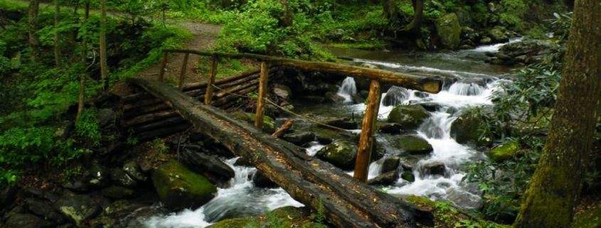
And with Brevard being so nearby, you have the ability to grab any last minute supplies you may need before entering the park for the weekend. Even better, the Pisgah Ranger Station is conveniently located across the street to help with any last minute adventure questions before you start your day. We suggest finding a campsite that sits along the Davidson River, offering you quick access to a trail that runs along the river—great for a moonlight hike.

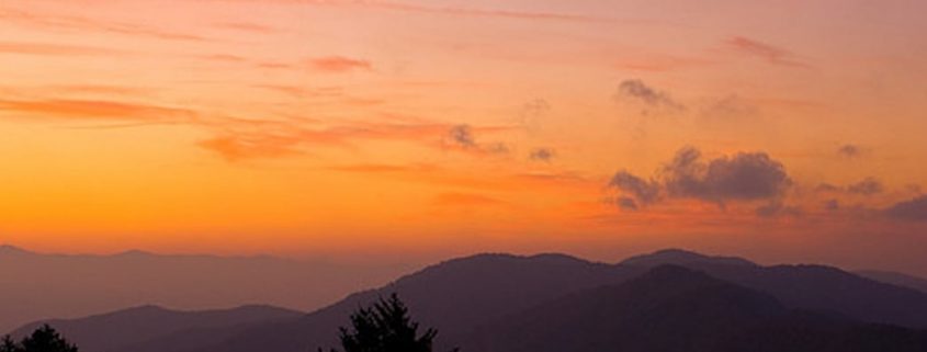
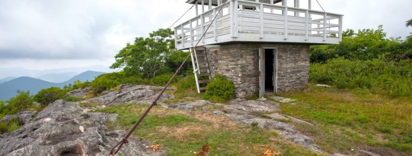
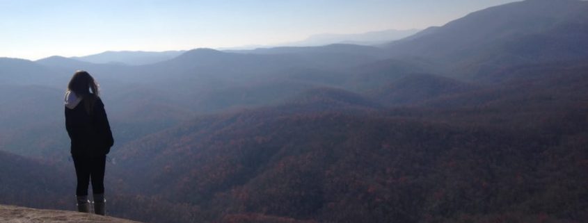
Saturday Morning Hike (7:30 am – 11:30 am): John Rock Loop

John Rock Loop
John Rock Loop

Jake Wheeler

Only a few miles from the Davidson Campground, start your day off by experiencing the stunning views of Pisgah’s gorgeous wilderness and mountains. Primitive tent camping is allowed here as well, so if you want to set up camp at the foot of John Rock, you may.

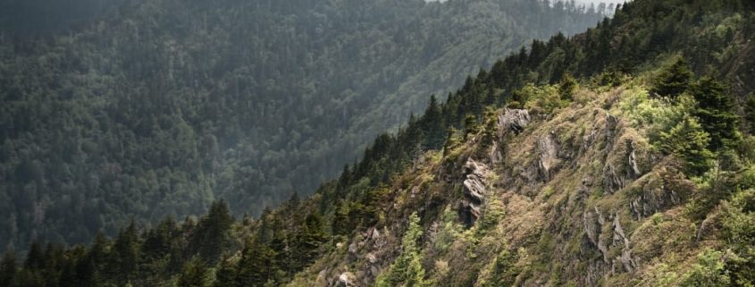
With over 1,000-feet of elevation gain, this 5.5-mile hike will get your blood pumping and your heart thumping. You will find yourself quickly shedding layers, as you walk through tunnels of rhododendron forests with the rising sun guiding you playfully along the trail. Once you get the top of John Rock, you are greeted with a huge rock slab that offers breathtaking views of the outstretching valley below, the Pisgah Ridge, and across the way to Looking Glass Rock.

Enjoy a light snack at the top, a quick drink of water, and prepare for a brisk walk down to the trailhead for your next stop… lunch!

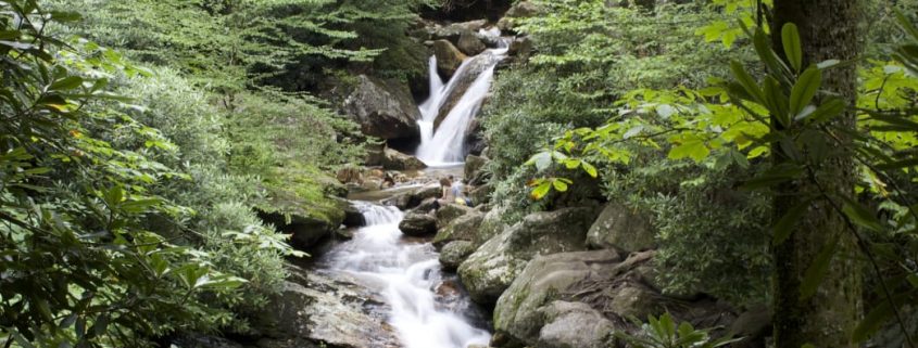
Lunch (12:00pm – 1:00pm): Looking Glass Falls

Only a short three-minute drive from the John Rock Loop Trailhead, enjoy a mountain meal with the accompanying sounds of the roaring 60-foot Looking Glass Falls. Pack your picnic basket and head just a few hundred yards from the parking lot and witness one of North Carolina’s most pristine and powerful waterfalls. Steps lead down to the base of the falls, making it easy to carry any lunchtime supplies and offering you a perspective that will truly humble you. Scramble around the rocks, watch out for ice in the winter seasons, and find a scenic spot to fuel up for your next adventure . . . Looking Glass Rock!

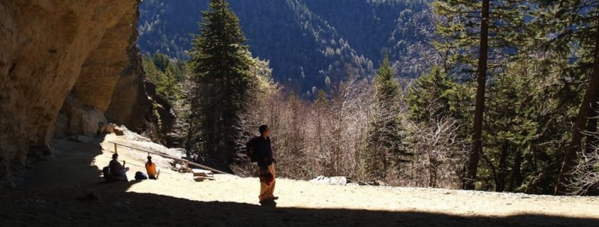
Saturday Afternoon Hike (1:30 pm – 4:30 pm): Looking Glass Rock

Looking Glass Rock
Looking Glass Rock

Jake Wheeler

Fill up your hydration pack and throw some nutrition in your pocket—you’ll need it. The trail to Looking Glass Rock is steep—climbing 1,700-feet in just over three miles and taking hikers and runners along a cascading mountain stream and through granite rock outcroppings and root gardens, which only add to the challenge. But after you weave through these hairpin switchbacks, and along trails coated with blankets of fall leaves, you’ll be rewarded with one of the most majestic views on the East Coast. The views are simply stunning! Definitely worth the physical expenditure.

The Pisgah National Forest offers great outdoor recreation possibilities for all ages and abilities. This is a great weekend trip for anyone looking to escape to the mountains. We recommend grabbing all your food needs in the town of Brevard before you escape. Whether it is your first time pitching a tent, or you’re a seasoned trail running vet, the Pisgah is a true slice of weekend adventure heaven.

JOIN OUR NEWSLETTER

Featured image provided by Jake Wheeler

There’s a bit of Tarheel pride in the fact that Mount Mitchell is the tallest mountain east of the Mississippi River. So important is the peak that, in 1915, it was named the first state park in North Carolina.

Mt. Mitchell didn’t just help to create N.C. State Park system though. At 6,684 it’s also responsible for creating its own climate and weather.

Because of its height, the climate at the top of Mt. Mitchell more resembles that of forests in the U.S. Northeast and Canada. During the Pleistocene era (pronounced play-stuh-seen so you can impress your friends), things were a bit colder in the region. Cooler temps allowed plants and animals normally found in northern climates to head south. Things warmed back up and these colder climate loving travelers were relegated to the highest peaks where altitude keeps things a bit chillier.

Lower average temps aren’t the only weather patterns that the mountain seems to control. On even otherwise clear days Mt. Mitchell can be ringed by mist. Warmer, wetter air is pushed to the top and cooled, condensing ambient moisture and creating a cloud. Unpredictable storms and wind are a common result.

The chance to view the world from on top of the east coast and watch the sunrise over the mists that settle in the valley more than make up for the unpredictable weather. While the roughly 12-mile round trip is commonly completed as a day hike, the best way to experience the all that the mountain has to offer is by taking an overnight backpacking trip.

The trip starts at the Black Mountain Campground, roughly an hour long drive from Asheville. Operated by the Cradle of forestry, this 46 site campground is a good accommodation alternative if you’d rather make the trek sans backpack. For this backpacking trip, though, you can park your car at the BMC lot at no charge.

From the BMC hit the Mount Mitchel Trail. After a steep climb, you’ll get to, well, more steep climbing. The backcountry camping area is four miles in on Commissary Ridge. It’s easy to spot as the trail flattens and you break free of the forest. Walk a few steps on the double track path and the meadow, complete with several obvious fire rings, is on the left.

Look around. There are some really nice but less obvious spots to set up camp located just down a small hill from the meadow. The stream you walked through on the way to your campsite is your water source. Filtering is a great idea unless you’re looking for a quick way to lose some pre-holiday weight.

Once you’ve ditched your pack and set up camp, finish the final 1.6 or so miles to the top of Mt. Mitchell. There are a couple different trail options near the top, it doesn’t matter which you take. As long as you’re going up, you’re doing it right.

As soon as you pop out of the forest again you’ll step onto the parking lot. There’s a paved road that brings drivers to the peak. (This explains why you saw the guy in motorcycle gear carrying a 20-ounce soda on the trail a few minutes before).

At the top, you’ll find bathrooms, a nature center, and a snack bar. The near famous elevation sign is to the right and the trail to the observation tower is to the left when facing the buildings. The 360-degree view from the tower makes the entire effort worthwhile.

After you’ve had your fill at the top, return to your campsite using the same trail you took up. Find a good seat for sunset. The mist settles in the lower valley for the evening and reflects the oranges and pinks of late afternoon. The best place to watch might be just past the campground on the dual track road. You can usually find firewood in this area as well.

Prepare for temps 10 degrees or colder than in Asheville. Bring appropriate rain gear even on the driest of days (you don’t want to be the one who temps fate just to save 8 ounces in your pack). And most importantly, have a good hike to the highest point east of the Mississippi!

JOIN OUR NEWSLETTER

Featured image provided by Rob Glover

Image for The Jump Off

Intro

Unique features are scatted throughout the Smoky Mountains, from deep valleys with quick rivers to steep summits with rocky slopes. Trails that explore this Appalachian diversity will stick in your memory and keep you searching for new favorite spots. With a steadily inclining segment of the infamous AT bringing you most all the way to one of the most unique viewpoints in the entire Smoky Mountain National Park, the Jump Off is well worth the walk.

What Makes It Great

The Jump Off is a notable 1,000-foot cliff face on the side of Mount Kephart. Once you see it, you’ll easily understand the name, as it produces magnificent views of Charlie’s Bunion and Mount Guyot from atop a very steep precipice. To get to this impressive landmark, one great option is to take the Appalachian Trail from Newfound Gap and connect it with the Boulevard Trail.

It’s a 6.5 mile out and back trail with quite a bit of climbing, but it’s generally pretty steady grade, so don’t be too worried. About 2.7 miles in, after you’ve conquered most of the elevation gain, you’ll reach the trail junction for the Boulevard Trail. Take a left here, and not before long, you’ll encounter the Jump Off junction, from where you’ll only have about half a mile left until your final destination. This trail provides great hiking in all seasons.

Diversity keeps things interesting on any trail, and this one does not disappoint. From the trailhead at Newfound Gap the path to the Jump Off steadily winds and ascends along the AT, giving breathtaking ridgeline views of the Smoky Mountain Highlands. Several large clearings along the way allow photo-ops for hikers that give a unique view of the surrounding forest. From these clearings, the destruction of the Hemlock Woolly Adelgid can be seen on neighboring mountains. The towering trees lining the trail often are surrounded with thick mosses and ferns, giving hikers the feel of wandering through a rainforest. During the winter months, the trail is often coved with ice like melted candle wax. During these colder months, the trail is more difficult but the added aesthetic of the ice makes an unreal experience.

Who is Going to Love It

Hikers, this trail is all yours. Trail runners will also enjoy the upward journey to this iconic mountain feature, but hikers will have the most enjoyable time. Because this is a section of the famed AT, many long-distance hikers will be passed along the way. This trek may even inspire you to do a long trip of your own.

Directions, Parking, & Regulations

Parking for the Jump Off is found at the Newfound Gap lot. The trailhead can be found at the edge of the parking lot, where the AT will be followed for 2.7 miles to the Boulevard Trail intersection. Once a left is taken onto the Boulevard Trail, the Jump Off trail will be on your left after about 0.5 miles. All of these trails are well marked.

Any backcountry camping requires a permit, and dogs are not allowed on the trail.

JOIN OUR NEWSLETTER

Featured image provided by Pen Waggener

Image for Alum Cave

Intro

A round trip of 4.4 miles, this trail starts with a pleasant walk through green canopies of rhododendrons, as you follow along a creek. The trail continues to give you plenty of nice photographic moments. The hike is moderate in difficulty but gets a little more strenuous as you close into the large overhang called Alum Cave. The scenery changes throughout the course of the trip, and there are several interesting geological features and pretty bridge crossings, which make this a great family hike. The “cave” is a great place to have lunch and reward yourself with a scenic view of the mountains. If you are wanting to do this hike, start as early as possible to avoid the crowds.

What Makes It Great

Any hike in the Smokies will provide great sights—this hike provides especially fantastic ones. Once you have begun climbing, several key (and incredibly interesting) landmarks will be passed. The trail actually goes under Arch Rock, the first key landmark (reached in just over a mile) and a great spot for a photo. Steps climb through the arch and show some of the geologic diversity that can be found in the Smokies. Continuing on, you will have expansive views from Inspiration Point. When you are looking out from this point, try to find the “Eye of the Needle,” a hole in the top of a rocky ridge nearby. Other than the views, the length of this trail is another great feature because of all that is available and seen within a short 4.5 miles. Many hikers set out to see the Alum Cave Bluff and end up enjoying the hike enough to continue on to the summit of Mount Le Conte. If you get to the “cave” and think that the views are spectacular, continuing on from there will not disappoint. Even if you do not wish to make it all the way to the top, continuing on provides increasingly great views as you go.

Who is Going to Love It

The short length of this hike makes it perfect for anyone. Families will love the accessibility of the car, and hardcore hikers will love the ability to continue on to the summit of LeConte. Alum Cave itself provides the perfect break spot, so feel free to take your time and enjoy the views out over the mountains from the turnaround point.

Directions, Parking, & Regulations

Parking for the Alum Cave Trail can be found on the main park road as it heads away from the Sugarlands Visitor Center towards Newfound Gap. There will be a roadside sign marking the trailhead, so park at the lot (which fills easily) and the trailhead will be quickly found. If you are planning to stay on LeConte, make sure to make reservations ahead of time.

JOIN OUR NEWSLETTER

Featured image provided by Snotgoblin

Near the trailhead for Mt. LeConte

Intro

Mt. Le Conte is one of the most iconic mountains in Great Smoky National Park. Not only is it the third highest point in the park, but it’s also the highest peak that is completely within the state of Tennessee, and from base to summit, it’s the tallest mountain east of the Mississippi. While these elevation accolades are certainly impressive, they don’t quite tell Le Conte’s entire story.

What Makes It Great

What really makes this mountain so special is its geological formations, biological variations, and historical fascinations. The mountain’s slopes are covered in ancient shale and sandstone as well as sweetly smelling spruce-fir forests. From the top, you’ll be treated to some of the most scenic views imaginable, and you’ll also come across LeConte Lodge, which is a series of cabins that were built in the 1920’s and which can only be accessed by trail. As for what trail?… Well, you’ve got options.

There are five routes, which lead to the summit of Mt. Le Conte. The two most popular of these is the Alum Cave Trail and the Boulevard Trail.

The Alum Cave Trail is the shortest, steepest, and most scenic route to the summit. From the trailhead to the top is 5.5 miles, so if you decide against staying the night at the lodge, you’re looking at an 11-mile round trip with quite a bit of elevation gain (about 2700 feet). Along the way, you’ll encounter a number of notable landmarks. At 1.3 miles in, you’ll come to Arch Rock, which is basically what the name implies: an arched rock. After passing through this naturally air-conditioned, cave-like section, you’ll pass Inspiration Point, which has some nice views and then at 2.2 miles in, you’ll reach Alum Cave Bluff, which is an 80-foot sight to behold. From here, the second half of your hike is the steepest. You’ll enter the Fraser Fir zone around 6,000 feet and then the trail will eventually (and at this point, gratefully) flatten out near the summit.

If you’re looking for a longer, less populated route, the Boulevard Trail is another great option. From the Newfound Gap parking lot, it’s 8 miles to the summit and 16 miles roundtrip. Though the 3,000 feet in elevation gain is stretched out over a longer distance than something like the Alum Cave Trail, it’s still 3,000 feet of climbing. Your legs will burn and your lungs will feel it. That being said, it’s a long, steady, gradual climb with views aplenty, so you’ll quickly find your rhythm. Along the way, you’ll pass junctions for Charlie’s Bunion and the Jump Off– both worth seeing if you’ve got the time and stamina. If not, continuing on for a straight shot to Mt. Le Conte will certainly suffice.

Whichever route you choose, you’ll certainly enjoy your day (or two) on top of Mt. Le Conte.

Who is Going to Love It

Anyone! This is one of the most iconic areas in the park, and anyone who feels up to the hike should take on this mountain. Hardcore hikers will enjoy this hike just as much as the weekend vacationers looking for a challenge, and photographers should check out the views at sunset or sunrise (bring plenty of warm clothes!). The difficulty is more than what is found in some other areas, but anyone can make it to the summit without too much trouble. If you time it right you may be hiking alongside the occasional morning mule train taking supplies up to the lodge!

Directions, Parking, & Regulations

Because of the varied routes for this trail, your parking depends on where you’re wanting to start out.

For the Alum Cave route, the trailhead can be found if you follow the road towards Clingman’s Dome. All parking areas are well marked.

As with all of the park, camping areas require permits that you may get from any Visitor Center.

JOIN OUR NEWSLETTER

Featured image provided by Jim R Rogers

Yellow Mountain

In a corner of the state inundated with undulating mountain chains and punctuated with soaring summits that include a generous number of 6,000-foot peaks, Yellow Mountain is far from western North Carolina’s loftiest summit at 5,127 feet in elevation. However, scaling this pinnacle of the Cowee Mountain chain involves one of the most punishing—and thoroughly rewarding—ascents in the southern Appalachians.

Aside from the brag-worthy climb, the craggy knob is also crowned with a historic fire tower that has become a well-weathered piece of Carolina mountain heritage. The tower guarantees that summit-baggers are rewarded with a seamless, panoramic view of the region. So lace up the hiking boots, load up on trail snacks, and head to western North Carolina to find out if the Yellow Mountain climb really is the hardest hike in the mountain-laden western corner of the state.

Yellow Mountain rises from a swath of the Nantahala National Forest between Cashiers and Highlands, and its ascent requires a 4.8-mile (9.6-mile roundtrip) hike on a trail loaded with plunging dips and gritty climbs—all foreshadowing an equally punishing return route. But climbing the highest peak in the Cowee Mountains requires not only summiting Yellow Mountain itself but three additional peaks as well.

Beginning at Cole Gap, the Yellow Mountain Trail kicks off with a bang as you almost immediately climb Cole Mountain before delving downward to Cole Gap and briefly bottoming out. Pits and pinnacles continue to dominate the trail, which continues on its way toward Shortoff Mountain. The ascent of Shortoff is dragged out along a series switchbacks snaking to the summit and reaching elevations of more than 5,000 feet.

After a short but sweet leveling out at the summit, the trail quickly becomes erratic once again, dipping and climbing toward Goat Knob, the third peak in the row on the Yellow Mountain ascent trail. From Goat Knob, the trail makes one more plunging drop, descending to Yellow Mountain Gap and intersecting a former Forest Service fire road. At Yellow Mountain Gap, the Appalachian Trail also crosses the track to the summit, providing a possibility for an even lengthier approach to the peak. (It also gives you the opportunity to add the Yellow Mountain ascent onto a multi-day backpacking trip.)

From the depths of Yellow Mountains Gap, the trail thankfully embarks on the final climb, ascending more than 2,000-feet to the top of the forest shrouded knob. At the summit, climbers are exponentially rewarded with a stunning panorama—an ocean of closely huddled southern Appalachian peaks stretching to the horizon. The 360-degree vista includes not only views of the rest of the Cowee Mountains that are nestled close to the Yellow Mountain summit, but it also showcases the Plott Balsam, Great Balsam, and the Great Smoky Mountains.

While the views of western North Carolina’s mountain-dappled landscape are spectacular, the unassuming, century-old structure sitting atop Yellow Mountain is arguably one of the summit’s most compelling highlights. Fire towers once peppered the southern Appalachians as solitary sentinels ensuring the safety of the surrounding wilderness. The steadfast smoke-watchers manning the structures acted as an early alarm system, tasked with thwarting the widespread devastation wrought by forest fires.

However, while some of the fire towers sprinkling the vast expanses of wilderness in the western United States are still in use, in the mountains of Appalachia, fire towers fell into disuse more than a half-century ago. Airplanes were deemed more efficient and economical for surveying seamless tracts of forest. The tower straddling Yellow Mountain’s summit was built in 1934, by Franklin Roosevelt’s Depression-era Civilian Conservation Corps, and it was used for more than three decades until 1969. Like many of historic towers dotting the Appalachians, the Yellow Mountain fire tower fell into disrepair when it was decommissioned. But thankfully it was preserved in the mid-1980s, and it’s now listed on the National Historic Register.

Plan Your Hike

Trailhead: The Yellow Mountain Trail is accessible from Cody Gap, off Buck Creek Road, off Route 64 about 8-miles west of Cashiers.

Additional Information: The distance can be deceiving: The 4.8-mile ascent may not seem staggering, but plan for the rugged terrain to add time to the hike. Allow at least a half day for the hike—around 4 to 6 hours—depending on hiking experience and fitness level. Plan to bring enough water to cover the entire trek.

JOIN OUR NEWSLETTER

Featured image provided by Nick Breedlove

Image for Charlie's Bunion

Intro

Delving into the etymology of Charlie’s Bunion reveals a historical tale of exploration during the earliest days of the Great Smoky Mountains National Park. Famed author and adventurer, Horace Kephart, was leading a reconnaissance trip high into the remote Saw-tooth region of the Smokies. This knife-edged ridgeline runs between the Mt. LeConte and Mt. Guyot massifs; its airy undulations are some of the most remote parts of the Park and a profile view, of the 10 mile stretch of peaks, resembles the serrated edges of a saw. Worn out from the rigors of exploration Kephart’s companion, Charlie Conner removed his boots during a break and revealed a set of haggard feet. His extremities resembled the nearby, and bulging outcropping of rocks known then as Fodderstack. Kephart, one of the Great Smokies’ greatest advocates, proposed renaming the rock Charlie’s Bunion to commemorate his misery.

What Makes It Great

Charlie’s Bunion, known to locals as The Bunion, can be reached by a 4-mile hike on the Appalachian Trail. A picturesque drive to Newfound Gap, a sight of the Park’s inauguration, leads to the start of this scenic hike. Forests of fragrant Firs line the rocky path and long range views will entertain your eyes as you make your way North on the AT. This particular section of the AT has a total elevation gain of 1,600’ and climbs to over 6,000’ on the sides of Mt. Kephart as it leads to The Bunion. Nearly 3 miles into the trail hikers are offered a reprieve from the rigors of trail life at the Icewater Springs Shelter. Bring a water filtration system and nourishment for a high country hiatus at this “life-list” shelter. Icewater Springs is home to amazing Appalachian views and a perpetually cold water source, making it an ideal resting point on your way to The Bunion.

Four miles into your hike a signed spur trail on your left will lead you in the direction of Charlie’s Bunion. Explore the area carefully, large drop-offs and loose rock here will require your utmost attention. Your reward for reaching the Bunion is paid off in views. The Bunion is walled in by the beautiful behemoths: Mt. Kephart Mt. Guyot and Mt. Leconte. An uninterrupted westward view, over the sprawling green expanse of Eastern Tenessee, opens up on the summit.

Who is Going to Love It

If you’re looking to experience the Appalachian Trail – sans blisters, and without having to walk all the way to Maine – then you will love this 8 mile, out-and-back sampling of the world famous trail. Adventurous scramblers will find a playground on The Bunion’s rocks and photographers can capture amazing sunset views from this precipitous peak.

Directions, Parking, & Regulations

From Asheville, an hour and a half drive will take you to the Newfound Gap parking lot where you will begin your hike northbound on the AT. Ample parking and restroom facilities are also available at Newfound Gap.

A day hike to the Bunion does not require any permits or fees.

If you wish to stay at the Icewater Springs shelter make reservations in advance, this shelter is quite popular, and plan on purchasing a permit for $4 per night, per person.

JOIN OUR NEWSLETTER

Featured image provided by Justin Meissen

Image for Graveyard Fields

Intro

The etymology behind Graveyard Fields is somewhat smoky. Centuries ago massive wind storms uprooted a once prominent spruce forest in this 5,000’ high, hanging valley. Root balls from the uprooted trees slowly decayed and overtime left behind mounds of dirt, similar to those found in ancient burial grounds. In more recent history, 1925 to be exact, a raging fire swept through Graveyard Fields. The fire destroyed everything in its path, including necessary nutrients in the soil. The high valley was left as a smoldering swath of land with “headstones” – the charred, stumpy remains of the spruce forest – strewn about the landscape.

What Makes It Great

Over time, leading up to the present day, Graveyard Fields has slowly recovered from its smoldering past to become a high altitude valley teeming with plant life. Today, visitors to Graveyard Fields will enjoy a mixture of Rhododendrons, Mountain Laurels, Blackberry and Blueberry bushes, high country grasses, and bouquets of wildflowers. Although the Fields have begun a long healing process their integrity is challenged annually by Graveyard Fields resounding popularity and all the inherent issues related to overuse by the outdoor community.

Visitors to Graveyard Fields can enjoy its splendors by way of a newly renovated trail system which includes elevated boardwalks, an intricately integrated bridge across Yellowstone Prong, and an expertly constructed waterfall overlook at Second Falls. Trails within Graveyard Fields can be combined to form a 3.2-mile loop which meanders through the relatively flat valley and includes views of Upper Falls and Second Falls. A detailed trail map sign stands at the parking lot, take a picture to reference later and begin your travels in either direction. Traveling the loop in a counterclockwise direction gives explorers an immediate reward, just .3 miles in, where a wooden staircase leads to the plunge pool below Second Falls. After returning to the start of the staircase the trail continues to wind through the high valley which is enclosed by the towering massif of Black Balsam Knob. As you work your way up the valley, beside a calm section of Yellowstone Prong, you will come to a signed trail leading to Upper Falls. Take this trail for a better chance of seclusion and a glimpse of Upper Falls.

Who is Going to Love It

Visitors in early Autumn will be treated to a dreamlike landscape, covered in the colors of Appalachia, and rich with ripe blueberries! The National Forest Service allows visitors to pick up to one gallon per person so bring a container and gather your fill. Summertime visitors can take advantage of the cooling waters of Yellowstone Prong in the plunge pool at the base of Second Falls. Savvy adventurers may even be able to find the picturesque Yellowstone Falls, just below Graveyard Fields, off of the Mountains-To-Sea Trail.

Directions, Parking, & Regulations

Parking for Graveyard Fields can be found at mile 418.8 on the Blue Ridge Parkway. A recently constructed solar-powered restroom facility sits in the parking lot which has 40 spots. If the parking lot is full venture to nearest overlook and make the trek back to Graveyard Fields. Fair warning, parking in the grass on the side of the road will likely earn you a citation on busy days!

Camping is allowed in several established sites within Graveyard Fields and dogs are welcome but must be kept on a leash at all times.

JOIN OUR NEWSLETTER

Featured image provided by Patrick Mueller

DuPont State Forest

Intro

DuPont State Recreational Forest is a beautiful 10,000-acre outdoor playground in the Blue Ridge Mountains. With roughly 80 miles of multi-use trails meandering through dense forests, alongside mountain lakes, and next to cascading waterfalls, DuPont is a hiker’s paradise.

What Makes It Great

Options are something you’ll have plenty of in DuPont. The 4.5-mile trail to Cedar Rock is a wonderfully scenic route with excellent views and not too much strenuous elevation gain. Both the short and long routes to the summit of Stone Mountain- the tallest point in DuPont- are grueling hikes with steep grades, yet amazing views. And hiking alongside one of the five lakes within DuPont is always a pleasant experience, most notably the 99-acre Julia Lake. But perhaps what DuPont State Forest is most known for is its waterfall hiking. The Little River flows through the park and creates four waterfalls on its way. Hooker Falls, Triple Falls, High Falls, and Bridal Veil Falls are all worth seeing, and you can actually reach three of these in one fell swoop on an easy 3-mile route. By parking at the Hooker Falls lot, you can reach the 12-foot cascade of Hooker in a matter of minutes, followed by a 1/2 miles jaunt upstream to the impressive 120-foot cascade of Triple Falls, and finally another 1/2 walk to the grand finale of 150-foot High Falls. After you’ve had your fill, simply turn around and return from where you came.

Who is Going to Love It

No matter what adventure you choose to have in the DuPont State Forest, it’s sure to be quite memorable for any nature lover. Oh, and movie lovers, a few scenes from “The Hunger Games” were filmed here, so that’s just the cherry on top.

Directions, Parking, & Regulations

From the DuPont State Forest website: “Take I-26 east toward the Asheville Airport. Exit at the Airport (exit 40) and head south on NC-280 for about 16 miles. Turn left onto US -64 (heading east) for about 4 miles. In Penrose, turn right onto Crab Creek Road for about 4 miles to DuPont Road. Turn right on DuPont Road and continue for 3.1 miles.”

JOIN OUR NEWSLETTER

Featured image provided by Osajus

Skinny Dip Falls

Intro

The waters of Yellowstone Prong spring from the peaks of the Great Balsam Mountains and gather themselves in Graveyard Fields. Born from springs above 6,000’ and purified through the 5,000’ meadow, these waters run crisp and clean. The perpetually cool waters flow peacefully through the hanging valley before plunging down a raucous ravine which leads to the Prong’s confluence with the East Fork of the Pigeon River.

What Makes It Great

From the mouth of Graveyard Fields the Yellowstone Prong cascades over the mighty Second Falls and then the secluded Yellowstone Falls. A short distance downstream the Prong makes its most risqué drop over Skinny Dip Falls. At this popular swimming hole a series of cascades and plunge pools line the banks of a heavenly ravine. A short, .5 mile walk from the Blue Ridge Parkway, leads to Skinny Dip falls where you can cool your body and refresh your soul in the wild waters of Appalachia.

Access to Skinny Dip Falls can be found right off the Parkway from the Looking Glass Rock overlook. Across the Parkway, from the overlook, a blazed spur trail leads into the woods. After taking this trail and entering the woods you will notice an Indian “Trail Tree,” which was formed as a trail marker by indigenous tribes. Perhaps they also enjoyed taking a dip, skinny style, in the Yellowstone Prong? After passing the ornate tree – some say the face of a dragon can be seen in its gnarled bark – hikers will come to an intersection with the Mountains-To-Sea trail. Veer left at this intersection and follow the rocky trail until reaching the swimming area. When you reach a wooden staircase leading to a bridge spanning the creek, you have arrived!

Enjoy yourself in the series of plunge pools, but please keep your clothing on if there’s a crowd. The falls are Skinny Dip by name only, not by nature during busy hours. A grouping of Boulders along the right side of the upper pool provides a platform to jump into the 6’ deep water. Use caution and make sure to hit your mark if you decide to take the leap off of the 8’-10’ rocks. The lower pools of Skinny Dip Falls are serenely beautiful and offer wading and lounging opportunities on their sun-soaked rocks.

Who is Going to Love It

Thanks to such easy access Skinny Dip Falls has become a highly popular area for families and adventurers. On warm summer days you are likely to share the water with a crowd. Fear not though, there are plenty of pools to spread the watery wealth. This swimming hole is in the vicinity of some incredible hiking trails. The Art Loeb, Mountains-to-Sea trail, Black Balsam Knob and Shining Rock are all within striking distance. Take a hike, then cap off your adventurous day by soothing your aching muscles in the waters of Skinny Dip Falls!

Directions, Parking, & Regulations

From Asheville catch the Blue Ridge Parkway near our Diamond Brand Outdoors’ South Location. Pick up your last-minute supplies there and then head south on the Parkway towards the Looking Glass Rock Overlook, located by mile marker 417.

Parking here is free but you may want to get there early on pretty summer days to find a spot.

Dogs are welcomed but should be kept on a leash until they are ready for a swim!

JOIN OUR NEWSLETTER

Featured image provided by Jenn Deane